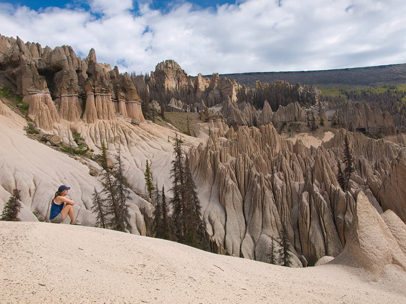
This beautiful landscape lies north up Pool Table and Hansens’s Mill Roads about 24 miles. (4x4 vehicle or ATV are required to access this area; trip takes between 8 and 10 hours.) These rock formations were formed by violent, spurting eruptions of volcanoes over sixty-five million years ago which deposited rock debris which unevenly eroded into spiral formations. From 1873 through 1884, George Wheeler and his survey team mapped this area, but never reached the Wheeler rock formations. Once known as a national monument administered by the National Park Service, it was later turned over to the U.S. Forest Service for safekeeping as a nationally-known geologic treasure. The La Garita Wilderness Area was expanded in 1993 by Congress and now includes the Wheeler Geologic Area, which can be explored by horse or foot only.

WheelerGeologicMonument B4Studio
Wheeler Geologic Monument, Photo by B4Studio

contentmap_plugin

Credits and Acknowledgments

The research, writing and production of this interpretive booklet were made possible by grants from the following generous organizations: Federal Highway Administration Intermodal Surface Transportation Efficiency Act (ISTEA), colorado Historical Society, Western Colorado Interpretive Association (WCIA), Hinsdale County Lodging Tax Panel, Lake City Chamber of Commerce, the Creede and Mineral County Chamber of Commerce, the Silver Thread Scenic and Historic Byway Council, and the Rio Grande Watershed Emergency Action Coordination Team. Special thanks to Grant Houston of the Hinsdale County Historical Society, Lynna Jackson of Creede, Nancy Houston, and the authors, Laurene Farley and Sandy Thompson of the U.S. Forest Service, Gunnison, Colorado. Layout and design update by B4 Studio, Creede.